Logements, Puteaux, 2023-2025, @Lanctuit Architectes
Housing, Puteaux, 2023-2025, @Lanctuit Architectes
.jpg)
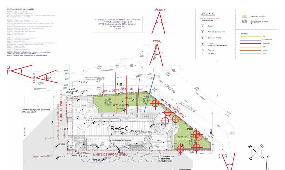
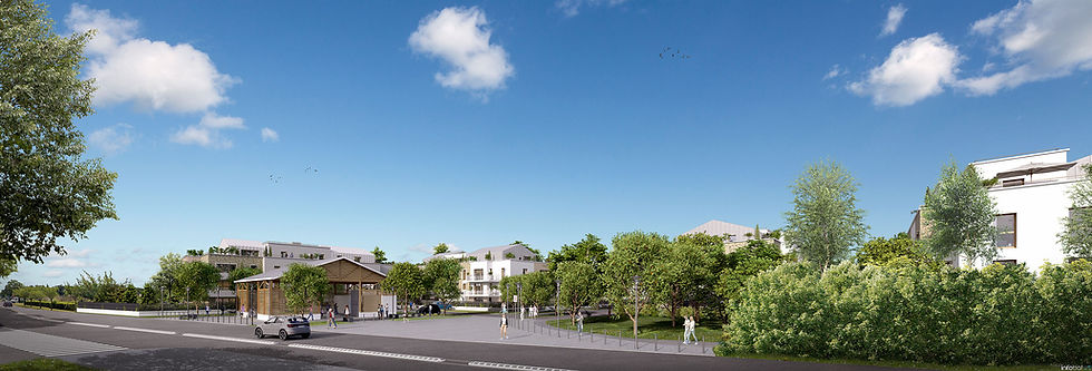
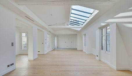
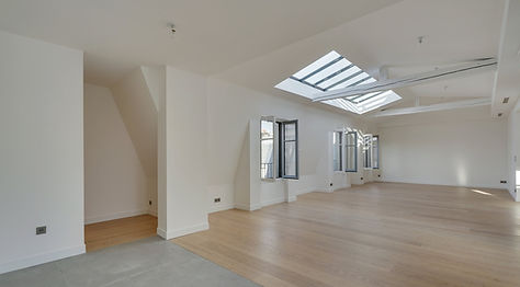
Le projet de Puteaux, avec le groupe Diagonale, a pour but de créer 16 logements collectifs, ainsi qu’un étage de bureaux.
La difficulté de ce projet réside en sa forme, contrainte par la réglementation PLU. Le bâtiment vient d’adosser à deux bâtiments mitoyens, situés en limite séparative. La répartition des logements s’articule autour d’un couloir situé en fond de parcelle, et d’un ascenseur permettant de desservir les étages.
La mairie souhaihait que nous reprenions des codes classiques, ainsi, nous nous sommes atelés à leur proposer des volumétries comprenant des éléments identifiables. Les éléments tels que les menuiseries métalliques, les gardes corps ciselés, les pilastres, les modénatures, renvoient l’image d’un immeuble bourgeois. L’ensemble du projet respecte la RE2020.
Mon rôle, au sein de l’équipe, a été d’établir des propositions à présenter à la mairie, en totale autonomie. J’ai ensuite préparé le Permis de Construire, pour continuer directement sur la phase DCE, en lien avec les différents acteurs du projet. Il fallait inclure les éléments envoyés par les Bureaux d’Etudes, tout en conservant la force architecturale du projet, validée par la mairie.
The Puteaux project, with the Diagonale group, aims to create 16 collective housing units, as well as an office floor. The difficulty of this project lies in its form, constrained by PLU regulations. The building has just attached to two adjoining buildings, located on the dividing line. The distribution of the accommodation is structured around a corridor located at the back of the plot, and an elevator providing access to the floors. The town hall wanted us to use classic codes, so we set about offering them volumes including identifiable elements. Elements such as the metal joinery, the chiseled railings, the pilasters, the moldings, convey the image of a bourgeois building. The entire project complies with RE2020. My role, within the team, was to establish proposals to present to the town hall, in complete autonomy. I then prepared the Building Permit, to continue directly with the DCE phase, in conjunction with the various project stakeholders. It was necessary to include the elements sent by the Design Offices, while retaining the architectural strength of the project, validated by the town hall.
Logements, Drancy, 2024, @Lanctuit Architectes
Housing, Drancy, 2024, @Lanctuit Architectes
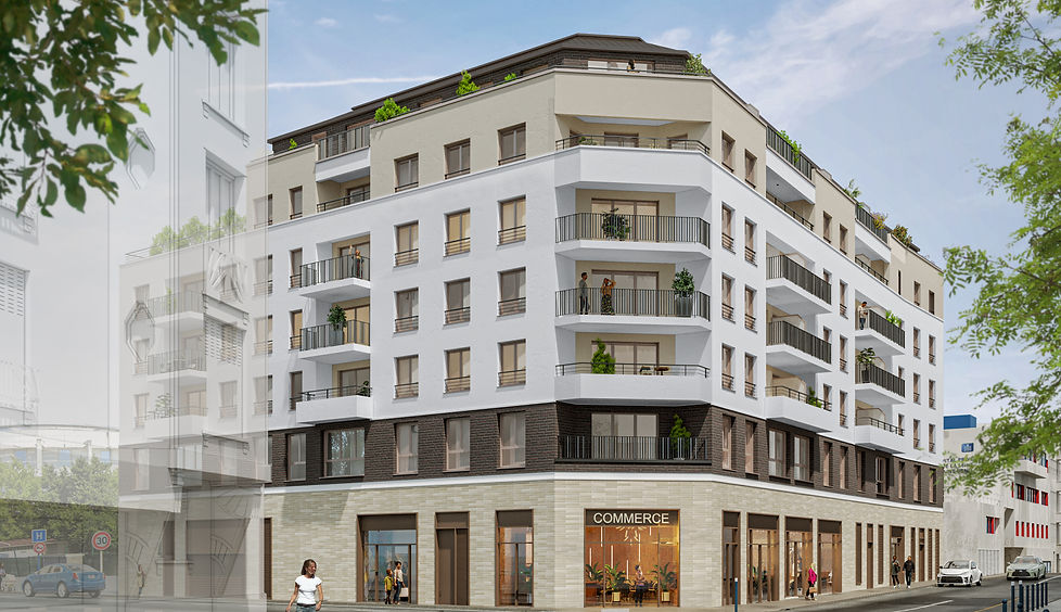
Le projet de Drancy se trouve à l’angle de deux voies, et à côté d’un bâtiment remarquable. Ainsi, le projet vient s’insérer dans le tissu urbain, et reprend la morphologie du bâtiment voisin : un soubassement marqué, avec commerce à RDC, un corps de bâtiment, et un couronnement.
Un des grands défis de ce projet a été de créer le parking, en escargot, avec demi-niveaux. Le client devait proposer assez de stationnement pour obtenir l’accord de la ville, et nous avons réussi à dessiner un bâtiment, avec deux cages, totalisant 55 logements et 73 places de stationnement.
Un système d’épannelage nous a permis de nous mettre en recul par rapport aux bâtiments voisins, pour alléger visuellement le projet. Nous avons aussi pu créer des terrasses, ainsi qu’un jardin sur dalle au premier niveau. Le projet totalise une emprise maximale sur la parcelle.
Mon rôle au sein de ce projet a été de déposer le Permis de Construire, puis de commencer le DCE, en autonomie partielle et contôle ponctuel. J’ai notamment aimé la difficulté à trouver un équilibre entre tous les éléments du programme, et réussir à satisfaire les demandes de la mairie d’un côté, et les attentes en termes de SHAB de notre client de l’autre.
(*les plans ne sont pas communiqués, car ils appartiennent à Lanctuit Architectes)
The Drancy project is located at the corner of two roads, and next to a remarkable building. Thus, the project fits into the urban fabric, and takes up the morphology of the neighboring building: a marked base, with a convenience store on the ground floor, a main building, and a crowning on the top floor. One of the big challenges of this project was to create the car park, in a snail shape, with half levels. The client had to offer enough parking to obtain approval from the city, and we managed to design a building, with two cages, totaling 55 housing units and 73 parking spaces. A paneling system allowed us to move back from neighboring buildings, to visually lighten the project. We were also able to create terraces, as well as a slab garden on the first level. The project has a maximum footprint on the plot. My role within this project was to submit the Building Permit, then start the DCE, with partial autonomy and punctual control. I particularly liked the difficulty of finding a balance between all the elements of the program, and succeeding in satisfying the requests of the town hall on the one hand, and the expectations in terms of spaces of our client on the other.
(* the plans are not communicated, because they belong to Lanctuit Architectes)
Logements, Rueil Malmaison, 2023, @Lanctuit Architectes
Housing, Rambouillet, 2023, @Lanctuit Architectes
Le concours de Rueil-Malmaison, non lauréat, présenté en 2023 avec Hibana, portait sur la transformation du site d’un ancien hôpital en parcelle d’habitation. L’objectif était de créer 3200 m² de SDP, comprenant 5 maisons individuelles.
Le parti pris du projet était de créer une première bande habitée sur rue, avec la présence des maisons, souvent reléguées en fond de parcelle. Elles peuvent ainsi créer une première échelle visuelle pour le piétons, et permettre de rendre le bâtiment collectif moins imposant. Le collectif, quant à lui, se divise en deux bâtiments en un seul volume, avec un porche permettant d’accéder en fond de parcelle. En effet, un accès piétons et cycliste y est prévu, grâce à une servitude de passage.
Pour ma part, je suis arrivée sur le projet trois semaines avant le rendu final. Ma mission était de dessiner le bâtiment collectif, pendant que ma collègue s’occupait des maisons. J’ai donc décidé d’intégrer un porche, qui desservirait la servitude au fond de la parcelle, tout en permettant l’accès au bâtiment collectif. Cet espace relie la forêt à la parcelle. J’ai aussi souhaité conserver des espaces extérieurs pour chaque appartement, quelle que soit leur typologie.
(*les plans ne sont pas communiqués, car ils appartiennent à Lanctuit Architectes)
The Rueil-Malmaison competition, which was not a winning project, was presented in 2023 in collaboration with Hibana. It focused on transforming the site of an old hospital into a residential plot. The goal was to create 3,200 sqm of gross floor area (GFA), including five single-family houses.
The design concept was to create an initial inhabited strip along the street, featuring the houses, which are often relegated to the back of the plot. This arrangement helps establish a first visual scale for pedestrians and makes the collective building appear less imposing. The collective, meanwhile, is divided into two buildings within a single volume, with a porch providing access to the rear of the site. Indeed, pedestrian and cyclist access is planned via an easement.
As for my involvement, I joined the project three weeks before the final submission. My task was to design the collective building, while my colleague handled the houses. I decided to include a porch that would serve the easement at the back of the plot and also allow access to the collective building. This space connects the forest to the site. I also aimed to preserve outdoor outdoor spaces for each apartment, regardless of their typology.
(* the plans are not communicated, because they belong to Lanctuit Architectes)
Logements, Rambouillet, 2020-2025, @Lanctuit Architectes
Housing, Rambouillet, 2020-2025, @Lanctuit Architectes
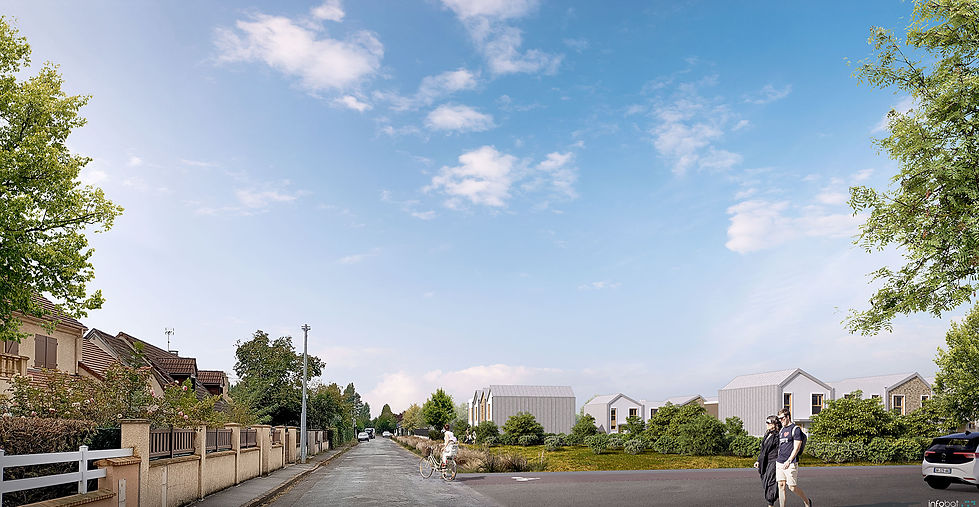
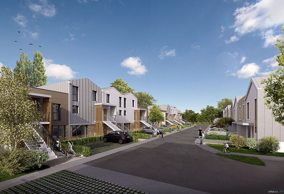
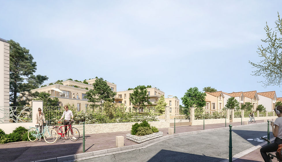
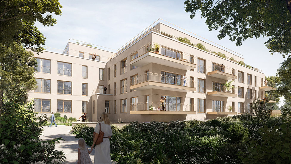
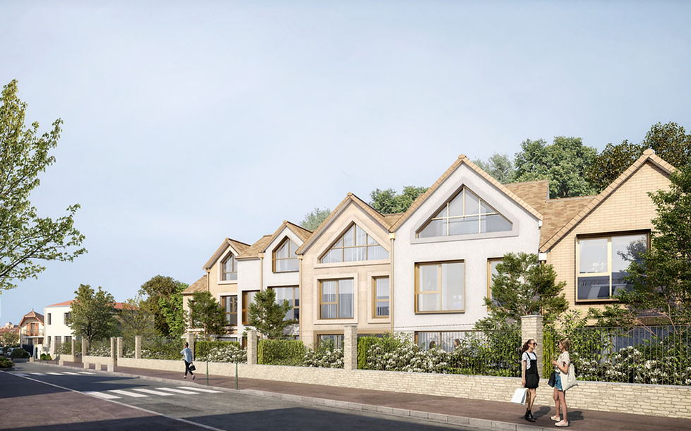
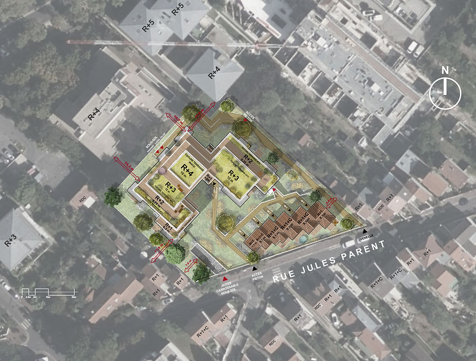
Le projet de Rambouillet, lancé en 2020, propose 250 logements de différents types, organisés en résidence. Bien que faisant partie globalement d’un tissu pavillonnaire, le site fait face, côtés Nord et Est, à quelques bâtiments à usage d’activité. Cette disparité de voisinage était donc à traiter. La réponse la plus élégante consistait à créer un plan de masse de transition, obtenu par la mise en place d’un épannelage dégressif du Nord au Sud créant une couture volumétrique entre les deux voisinages. Une variation de hauteur du bâti partant de petits collectifs de deux étages + attique face au tissu urbain d’activité au format de maisons d’individuelles d’un étage face au tissu pavillonnaire. Outre le programme de logements, le projet prévoit la construction d’une halle le long de la rue de la Louvière. Ce bâtiment favorisera les rencontres et la convivialité entre les habitants du quartier.
L’objectif est « d’ouvrir » la résidence sur l’extérieur, d’assurer le libre passage des vues des circulations douces, permettant un libre passage aux petits animaux favorisant le respect de la biodiversité. En conséquence, le plan de masse reprend un schéma en damier. Les bâtiments sont de petites tailles, non adossés les uns aux autres, laissant des aérations ouvertes à la circulation ou juste en percée visuelle qui, par leur alignement, offre une respiration à la résidence sur ces deux axes de conception : l’axe Nord-Sud et l’axe Est-Ouest.
L’orientation Est-Ouest des bâtiments collectifs et intermédiaires a été privilégiée afin de limiter les façades Nord. L’ensemble des maisons individuelles est orienté de manière à n’avoir aucun séjour orienté au Nord.
Mon rôle quant à ce projet fut l’élaboration d’un PCM, lors de la découverte d’une zone humide. Nous avons du retirer une cinquantaine de maisons, et repenser le plan masse général. De plus, j’ai du étudier le DCE ainsi que l’AMT, en échangeant avec le client et les différents bureaux.
Suite à cela, il a fallu sortir dans des délais courts l’ensemble des plans de vente des logements, aussi bien collectifs, qu’intermédiaires et individuels.
Selon les période, j’ai travaillé seule, en autonomie relative, et contrôle ponctuel, ou en équipe pour les sorties de plans généraux, en raison du «poids» de la maquette générale, et du processus de collaboration de REVIT. Le fait de travailler en BIM, avec une maquette générale, et des maquettes de liens intégrées, nous a permis de travailler de manière plus efficace lors des périodes de travail en groupe (3 personnes au maximum). Ce projet fut le plus important projet de l’agence de l’année 2023. J’ai particulièrement apprécié le travail en BIM, et pu développer mes compétences aussi bien sur REVIT qu’en terme d’organisation.
(*les plans ne sont pas communiqués, car ils appartiennent à Lanctuit Architectes)
The Rambouillet project, launched in 2020, offers 250 housing units of various types, organized into a residence. Although it is mostly part of a suburban fabric of individual houses, the site faces, on the North and East sides, some buildings used for commercial or industrial purposes. This neighborhood disparity needed to be addressed. The most elegant solution was to create a transitional massing plan, achieved through a gradual setback from North to South, creating a volumetric seam between the two types of neighborhoods. This involved varying the building heights, starting with small apartment blocks of two floors plus attic facing the urban activity fabric, and single-story houses facing the suburban fabric. In addition to the housing program, the project includes the construction of a hall along Rue de la Louvière, which will promote social interactions and conviviality among neighborhood residents.
The goal was to "open" the residence to the outside, ensuring clear views along pedestrian pathways, allowing unobstructed access for small animals and supporting biodiversity. Consequently, the massing plan adopts a checkerboard pattern. The buildings are small, not attached to each other, leaving open spaces for circulation or visual glimpses that, through their alignment, provide breathing space for the residence along two axes: north-south and east-west. The east-west orientation of the collective and intermediate buildings was prioritized to limit the north-facing façades. All the individual houses are oriented so that no living rooms face north.
My role in this project involved developing a PCM (Project Common Masterplan) after discovering a wetland area. We had to remove about fifty houses and rethink the overall massing plan. Additionally, I studied the DCE (Design and Construction Description) and the AMT (Technical Assistance Mission), communicating with the client and various offices. Following that, it was necessary to quickly produce the sales plans for all housing units, including collective, intermediate, and individual homes.
Depending on the period, I worked independently with relative autonomy and occasional reviews, or as part of a team for the release of general plans, due to the complexity of the master model and the REVIT collaboration process. Working in BIM, with a master model and linked models, allowed us to work more efficiently during group work periods (up to three people). This project was the most significant one for the agency in 2023. I particularly enjoyed working in BIM and was able to develop my skills in REVIT as well as organizational skills.
(* the plans are not communicated, because they belong to Lanctuit Architectes)
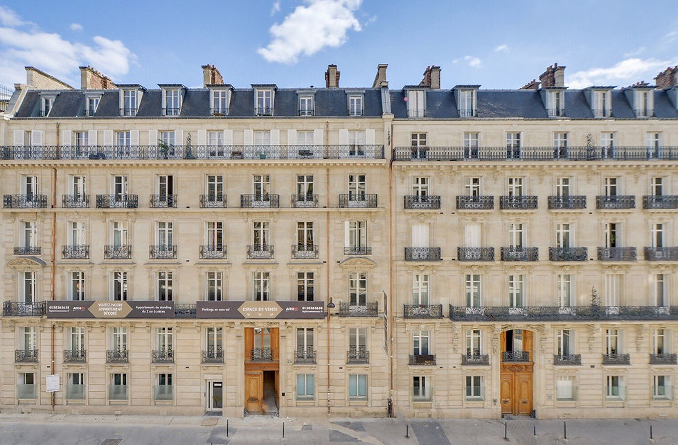
Le projet était de rénover trois immeubles haussmanniens, en plein cœur de la Plaine Monceau. La surface totale de ces trois bâtiments était de 14000 m². Il s’agissait de refaire une grande partie des appartements, mais aussi l’ensemble des parties communes, et de transformer les derniers étages de chambres de bonnes en lofts. Nous avons repris le projet avant le PC. La Maîtrise d’Ouvrage souhaitait que la rénovation soit faite de manière luxueuse, dans le respect du budget. De même, nous devions refondre les plans généraux, pour agrandir certains lots, fermer des courettes, penser de nouvelles verrières, etc. Nous avions une quinzaine d’appartements en travaux de manière constante, avec autant d’entreprises en intervention. La difficulté du projet est que tous les travaux avaient lieu sur un site semi-occupé.
Ma mission sur ce projet a été de redessiner six appartements en limitant un budget, et de créer les six lofts très hauts de gammes, ainsi que d’assurer le suivi de chantier, passer régulièrement pour contrôler le bon déroulement de celui-ci, et d’assurer une partie des rendez vous avec les autres acteurs de la maîtrise d’oeuvre: MOE plomb et amiante, ingénieurs, etc. Je me suis aussi occupée du suivi financier du chantier.
(*les plans ne sont pas communiqués, car ils appartiennent à ROM)
The project was to renovate three Haussmann buildings, in the heart of the Plaine Monceau. The total area of these three buildings was 14,000 m². It involved renovating a large part of the apartments, but also all of the common areas, and transforming the top floors , composed of maids' rooms, into lofts. We took over the project before the Permit of Building. The client wanted the renovation to be extremely luxurious, with a budget. Likewise, we had to recast the general plans, to enlarge certain lots, close courtyards, think of new windows, etc. We had about fifteen apartments under construction on a constant basis, with as many enterprises in intervention. The difficulty of the project is that all the works were taking place on a semi-occupied site.
My mission on this project was to redesign six apartments while limiting a budget, and to create the six very high-end lofts, as well than to ensure the monitoring of the site, to visit regularly to check the smooth running of it, and to ensure part of the meetings with the other actors of the project management. I also took care of the financial monitoring of the site.
(* the plans are not communicated, because they belong to ROM)


Ecole, Puteaux, 2019, @ROM
College, Puteaux, 2019, @ROM
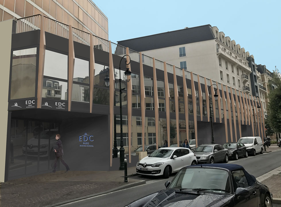
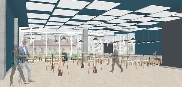
Le projet est de transformer un immeuble de bureaux en école de commerce (ERP). Le bâtiment existant monte jusqu’à R+7. L’objectif
était de créer des salles de classe, une cafétéria, un accueil. Nous voulions conserver la structure du bâtiment existant, pour modifier en
profondeur l’organisation interne, les façades, et les circulations. Pour que le projet soit classé ERP, nous avons aussi dessiné un escalier extérieur. Nous nous sommes occupés du PC, de l’ensemble des phases avant et après le permis, et du suivi des travaux. La partie intéressante de ce projet était le changement de destination, et donc le fait qu’il fallait repenser les circulations au sein de ce bâtiment.
Nous avons souhaité rajouter un bardage «mouvant» sur la façade principale, en bois. L’objectif était de créer un rythme en façade.
(*les plans ne sont pas communiqués, car ils appartiennent à ROM)
The project is to transform an office building into a business school (Etablishment open to the public). The existing building goes up to Floor 7. The goal was to create classrooms, a cafeteria, a reception. We wanted to keep the structure of the existing building, to modify in depth of internal organization, facades, and circulation. So that the project is classified ERtabishment open to the public, we also designed an external staircase. We took care of the building permit all the phases before and after the permit, and monitoring the work. The interesting part of this project was the change of destination, and therefore the fact that it was necessary to re-think circulations within this building. We wanted to add a "moving" wooden cladding on the main facade. The aim was to create a rhythm on the facade. (* the plans are not communicated, because they belong to ROM)
Towaa, Rikuzentakata, Japon, Diplôme, 2018, @ESA
Towaa, Rikuzentakata, Japan, Diploma, 2018, @ESA
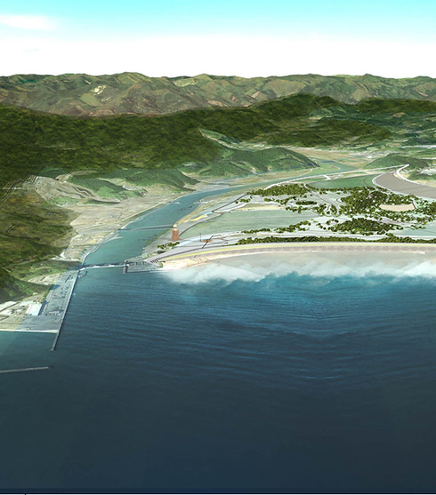
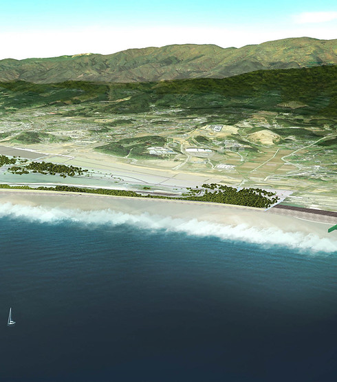
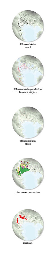
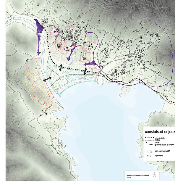
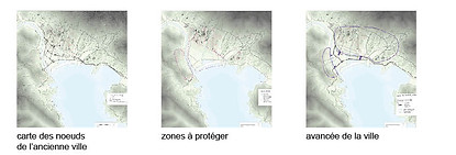

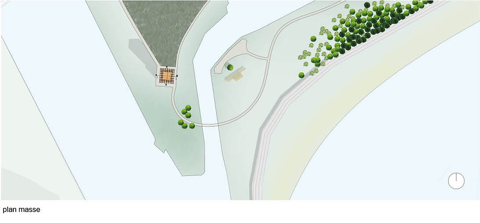
La ville de Rikuzentakata, dans la préfecture d’Iwate, a été sévèrement touchée par le tsunami du 11 mars 2011. Elle a été rasée à 85%, laissant un champs de ruines. Presque 7 ans plus tard, la ville commence à se reconstruire. Toutefois, le plan de reconstruction proposé par la mairie n’empêchera pas l’avancée de la ville, au fur et à mesure des années, quand la catastrophe deviendra un souvenir lointain.
La problématique principale d’une telle ville est de reconstruire en pensant à l’après, il faut faire en sorte que les générations futures ne se ré-installent pas dans la vallée, trop dangereuse et bien trop souvent touchées par des tsunamis.
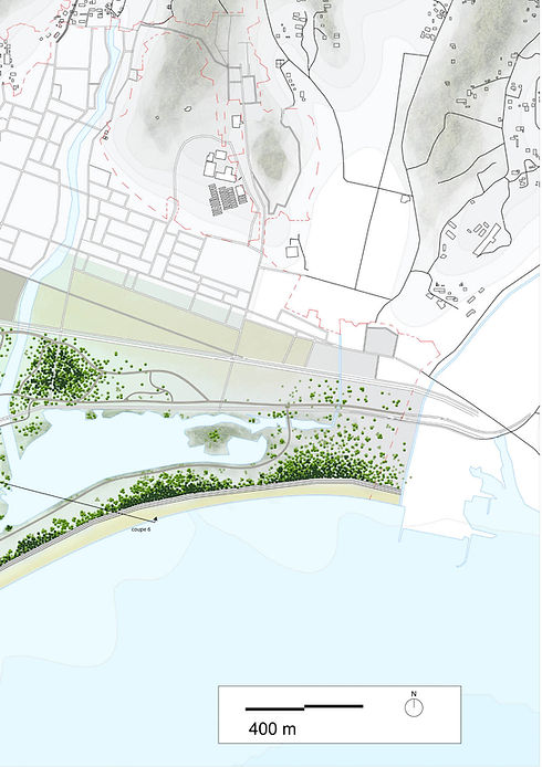
Une des possibilités de projet est de construire un parc commémoratif, là où l’ancienne ville se trouvait. L’avancement urbain serait bloqué par divers éléments: centre sportif, recyclerie, potagers collectifs. Au centre, un grand parc viendrait relier les deux parties de la ville. Il agirait comme un élément que les habitants doivent se réapproprier. Deux collines viendraient se former, bien au dessus de 17,60 m, hauteur de la vague. L’ancienne lagune serait conservée, pour créer un frein naturel en cas de tsunami. Plusieurs éléments différents existent dans le parc. La lagune, d’abord. Elle constitue un frein à l’avancée d’un tsunami, et recrée une mer intérieure. Ensuite, une seconde lagune sera créée au nord. Elle agit comme un lac, et interroge sur la place de l’eau. Une forêt de pins sera replantée le long de la digue. Des espaces de grands plans et de petits plans se rencontreront.
Sur la presqu’île de la lagune, des petits plans s’essemeront avec le temps. Les espaces de potagers collectifs seront poreux: ils auront la possibilité de s’étendre. De même, un vaste espace engazonné sera libéré au nord du parc, en relation directe avec le centre sportif, pour créer des espaces de jeu plus sauvages. Enfin, un jardin sec viendra créer la surprise au milieu d’une densité verte, et interrogera sur l’ancien paysage. Un parc, au Japon, est un espace créé pour interroger, et non pas pour apporter des réponses.
Les collines offriront des points de vue sur le parc commémoratif. Une étendue de petits plans, qui poussent avec les saisons, viendront créer un espace de jeu naturel pour les enfants. Cet espace se trouve sur la «corne» du parc, au bout de celle-ci se trouvera le mémorial-futurial, agissant comme un signal au sein de la vallée. D’une hauteur de 50 m, il sera visible des deux flancs de la ville.
The town of Rikuzentakata, in Iwate prefecture, was severely affected by the tsunami of March 11, 2011. It was 85% razed, leaving a field of ruins. Almost 7 years later, the city begins to rebuild itself. However, the reconstruction plan proposed by the town hall will not prevent the advance of the city, as years go by, when the disaster becomes a distant memory. The main problem of such a city is to rebuild while thinking of the future, we must ensure that future generations do not resettle in the valley, too dangerous and all too often affected by tsunamis.
One of the project possibilities is to build a memorial park, where the old city stood. Urban advancement would be blocked by various elements: sports center, recycling center, collective vegetable gardens. In the center, a large park would connect the two parts of the city. It would act as an element that the inhabitants must reclaim. Two hills would form, well above 17.60 m, height of the wave. The old lagoon would be preserved, to create a natural brake in the event of a tsunami. Several different elements exist in the park. The lagoon, first. It hinders the onset of a tsunami, and recreates an inland sea. Then, a second lagoon will be created to the north. It acts like a lake, and questions the place of water. A pine forest will be replanted along the dike. Spaces of large plans and small plans will meet.
On the peninsula of the lagoon, little plans will sprout up over time. The collective vegetable garden spaces will be porous: they will have the opportunity to expand. Likewise, a vast grassed area will be released to the north of the park, in direct relation to the sports center, to create wilder play areas. Finally, a dry garden will surprise you in the midst of a dense green, and will question the ancient landscape. A park, in Japan, is a space created to question, and not to provide answers.
The hills will offer views of the memorial park. An expanse of small plans, which grow with the seasons, will create a natural play area for children. This space is located on the "horn" of the park, at the end of it will be the memorial-futurial, acting as a signal within the valley. At a height of 50 m, it will be visible from both sides of the city.


Le projet est pensé comme un mémorial-futurial. L’objectif d’une telle installation est de permettre aux habitants de se retrouver, pour
se souvenir, mais aussi de leurs offrir des espaces de vie, des lieux collectifs, de rendez-vous. Les espaces de vie manquent cruellement
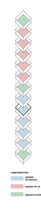
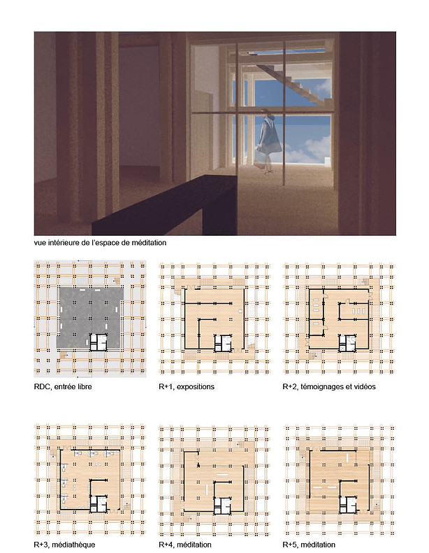
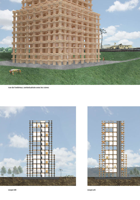
au sein même de la ville. Le RDC est un espace ouvert, dans la prolongation d’un espace vivant planté. La trame apparait. Tous les 3m, un poteau. Seule la trame des escaliers est plus resserrée. Concernant les espaces de mémoire, une double trame-escaliers vient enrober les plateaux. Les étages mémoires sont plus sombres, plus renfermés. A partir de R+4, la trame devient libre, pour montrer la hauteur de la vague, et le fait que la vie reprend son cours, avec des programmes plus vivants.
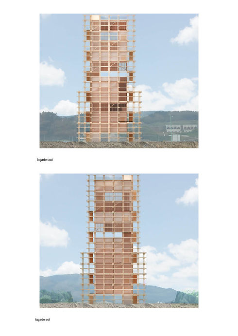
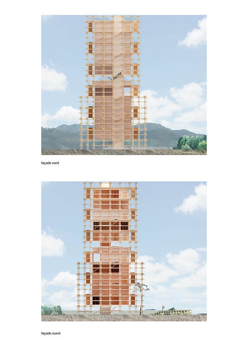
La structure bois est visible à chaque étage. L’objectif est de réutiliser le bois local, car la ville de Rikuzentakata est très fière de ses forêts de sugi et de hinokis. Ces grands arbres sont utilisés dans les maisons traditionnelles. La tour est située vers les ruines restantes, conservées par la ville comme souvenirs de la catastrophe. Le bâtiment était un ensemble de bureaux, et le «miracle pine» est l’unique survivant d’une forêt de 77.000 pins rasés par la vague.
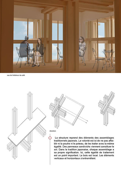
Les plans sont libres, seules des cloisons viennent délimiter les espaces intérieurs. Ce choix s’explique car le but est de créer des espaces modulables, pour que les habitants viennent réinvestir cette tour. Ayant été les grands oubliés du plan de reconstruction de la mairie, cette tour leur est totalement dédiée, et devient un espace de réunion. Les accès ne sont pas réglementés. Les japonais sont respectueux, et la tour ne risque pas d’être dégradée de manière malveillante. Avec un doubles escaliers de chaque coté, les points de vue sont multiples. Il s’agit d’un espace intermédiaire, qui a sa propre importance. Ils constituent le lien entre l’intérieur et l’extérieur.
La structure reprend des éléments des assemblages traditionnels japonais. La volonté est ici de ne pas affaiblir ni la poutre ni le poteau, de les traiter avec la même égalité. Des panneaux sandwichs viennent constituer le sol. Dans la tradition japonaise, chaque assemblage a
sa propre signification. Ici, cette égalité de traitement est un point important. Le bois est local. Les éléments verticaux et horizontaux s’entremêlent.
The project is conceived as a memorial-futurial. The objective of such a facility is to allow residents to meet, to give them a place to remember, but also to offer them living spaces, collective places, meeting places. Living spaces are lacking in the city. The ground floor is an open space, an extension of a planted living space. The frame appears. Every 3 m, a post. Only the frame of the stairs is tighter. Regarding the memory spaces, a double staircase frame wraps the trays. The memory floors are darker, more withdrawn. From R + 4, the frame becomes free, to show the height of the wave, and the fact that life resumes its course, with more living programs.
In addition to this, you need to know more about it. The wooden structure is visible on each floor. The aim is to re-use the local wood, as the town of Rikuzentakata takes great pride in its sugi and hinoki forests. These large trees are used in traditional houses. The tower is located towards the remaining ruins, preserved by the city as souvenirs of the disaster. The building was an office complex, and the "miracle pine" is the only survivor of a forest of 77,000 wave-razed pines.
The plans are free, only partitions delimit the interior spaces. This choice is explained because the goal is to create modular spaces, so that the inhabitants come to reinvest this tower. Having been largely forgotten in the town hall reconstruction plan, this tower is totally dedicated to them, and becomes a meeting space. Access is not regulated. Japanese poeple are very respectful, and the tower is unlikely to be maliciously degraded. With a double staircase on each side, the points of view are multiple. It is an intermediate space, which has its own importance. They are the link between the inside and the outside.
The structure incorporates elements of traditional Japanese assemblages. The will here is not to weaken either the beam or the post, to treat them with the same equality. Sandwich panels form the floor. In Japanese tradition, each blend has its own meaning. Here, this equality of treatment is an important point. The wood is local. The vertical and horizontal elements intertwine.

Mercado do Coimbra, Coimbra, Portugal, Licence, 2016, @ESA
Mercado do Coimbra, Coimbra, Portugal, Semester6, 2016, @ESA

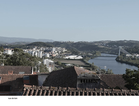
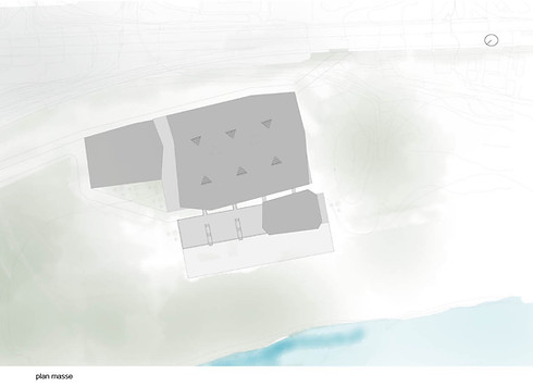
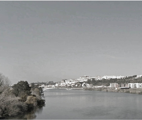
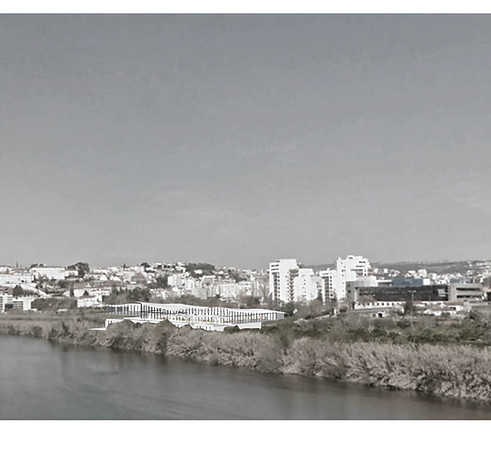
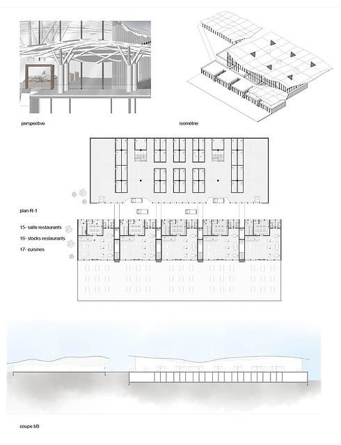
La ville de Coimbra, au Portugal, est caractérisée par la densité de son centre ville. La partie historique de la ville est remplie de boutiques, de cafés, de lieux de vie. Les autres quartiers, moins centraux, peuvent être considérés comme des dortoirs. La circulation automobile y est extrêmement valorisée, au détriment de la circulation pédestre. Peu de commerces de proximité et autres équipements se trouvent dans ces quartiers. Les habitants sont obligés de prendre la voiture, pour aller faire leurs courses dans des hypermarchés, qui constituent des dents creuses au sein de la ville. Coimbra est séparée en deux rives par le Rio Mondego. Petit à petit, les berges sont réinvesties par les habitants. L’objectif du projet est donc de réunir les habitants des trois quartiers du site. Nous avons choisi ce terrain, sur une rive du fleuve, car il constitue un carrefour important dans la ville. Il serait intéressant de redonner aux habitants un lieu de vie, un espace où ils pourraient se retrouver, discuter, tout en faisant leurs courses. Ainsi, nous sommes arrivées à un point où le programme s’est imposé à nous: un marché couvert, avec des restaurants, sur les berges du Mondego.
Un marché est une véritable machine: il faut des stocks, des espaces de vente, et des espaces administratifs d’où gérer l’organisation du marché. L’identité de Coimbra est aussi caractérisée par la présence de nombreuses collines. Mon projet de marché souhaite rendre hommage à la topographie, avec à la fois des ouvertures pour créer des vues sur la ville, mais surtout un toit collinaire. Le système poteau-poutre paraissait adapté à cette volonté de renvoyer à la topographie du site. Les poteaux seront arborescents, sur lesquels viendrait se poser une trame de poutres, dans trois sens différents, qui viendrait soutenir la toiture, ouverte par endroit, pour
permettre une ventilation naturelle du lieu. Sous chaque poteau, il y a un étale, qui est relié aux stocks en dessous.
The city of Coimbra, Portugal, is characterized by the density of its city center. The historic part of the city is filled with shops, cafes, living places. Other less central neighborhoods can be considered as dormitories. Automobile traffic is highly valued there, to the detriment of pedestrian traffic. Few local shops and other amenities are found in these areas. The inhabitants are forced to take the car, to go shopping in hypermarkets, which constitute hollow teeth in the city. Coimbra is separated into two banks by the Rio Mondego. Gradually, the banks are reinvested by the inhabitants. The objective of the project is therefore to bring together the inhabitants of the three districts of the site. We chose this land, on a river bank, because it is an important crossroads in the city. It would be interesting to give the inhabitants a place of life, a space where they could meet, discuss, while doing their shopping. Thus, we came to a point where the program imposed itself on us: a covered market, with restaurants, on the banks of the Mondego.
A market is a real machine: you need stocks, sales areas, and administrative areas where you can manage the organization of the market. The identity of Coimbra is also characterized by the presence of numerous hills. My market project wishes to pay tribute to the topography, with both openings to create views of the city, but above all a hilly roof. The post-beam system seemed suited to this desire to refer to the topography of the site. The posts will be arborescent, on which a frame of beams would rest, in three different directions, which would support the roof, open in places, to allow natural ventilation of the place. Under each post there is a stall, which is connected to the stocks below.

Point d'enseignement, Paris, Semestre 5, 2015, @ESA
Teaching Point, Paris, Semester 5, 2015, @ESA

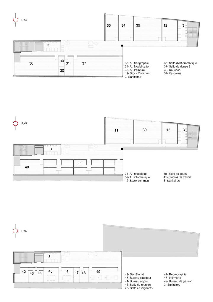
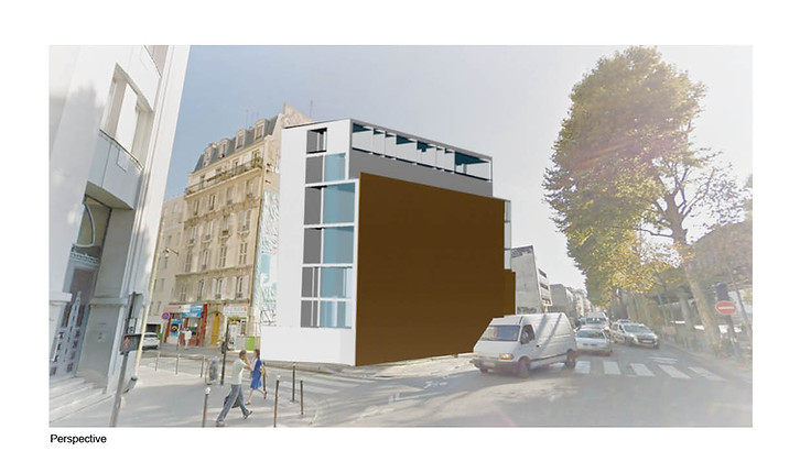
Le projet était de dessiner une école d’arts boulevard de la Chapelle, à Paris. Le site se trouve à l’angle de deux rues très fréquentées, en face du métro aérien. L’école serait un espace pour les loisirs extrascolaires, profitant aux habitants du quartier. En prolongeant les lignes de force du site, (la parallèle du boulevard de la Chapelle, et celle de la rue Philippe de Girard), nous obtenons un point, qui sera le centre du projet. Ces lignes séparent le site en quatre parties, qui «tournent» autour du point. Chaque partie du site deviendra alors une partie de l’école: la première zone, ce sera le jardin de l’entrée. A sa gauche, une partie dense et fermée à la rue, composée de salles de classes. Cette zone est ouverte sur le jardin intérieur. La partie plus en dedans du site sera l’amphithéâtre, surplombé d’un jardin suspendu. Enfin, la dernière partie sera composée d’espaces de réunions et de salles de classes.
Les salles d’arts sont orientées vers le nord, pour bénéficier d’une lumière froide et stable. Enfin, le jeu de ce projet est de libérer des espaces ouverts sur l’extérieur uniquement aux salles ayant besoin d’éclairage. Les stocks, par exemple, sont des pièces aveugles. Le site
et sa dynamique souhaitait que le projet soit accroché aux murs pignons avoisinants. Ainsi, ce projet essayent de tirer partie de cela. D’une manière générale, les ouvertures ne sont pas directement sur la rue, mais créent des vues au sein même du site, pour limiter les nuisances sonores. La présence d’espaces verts permet aux étudiants du quartier de profiter de leur école non pas uniquement dans un cadre scolaire, mais aussi de recréer des espaces de lien social. L’école bénéficie d’une cafétaria, de cuisines, d’une bibliothèque, conformément au programme qui nous avait été donné.
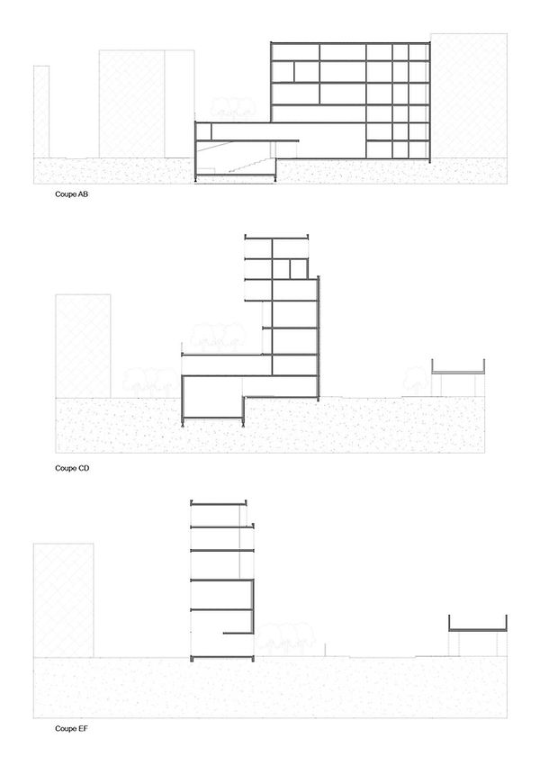
La façade donnant directement sur la rue est fermée, et bénéficie d’un bardage bois. La seconde façade, donnant sur le jardin d’entrée,
n’est que partiellement fermée. Seuls les R+1 et 2 sont clos. Le bâtiment bénéficie de quatre parties distinctes, et donc de 4 niveaux différents. La première au niveau du sol, puis son opposée jusqu’à r+2. Les deux parties «hautes», composées surtout de salles de classes, bénéficient aussi des niveaux différents.
The project was to design an arts school on Boulevard de la Chapelle, in Paris. The site is located on the corner of two busy streets, opposite the skytrain. The school would be a space for extracurricular recreation, benefiting the residents of the neighborhood. By extending the main lines of the site (the parallel of the boulevard de la Chapelle, and that of the rue Philippe de Girard), we obtain a point, which will be the center of the project. These lines separate the site into four parts, which "revolve" around the point. Each part of the site will then become part of the school: the first area will be the entrance garden. To its left, a dense part closed to the street, made up of classrooms. This area is open to the interior garden. The inner part of the site will be the amphitheater, topped by a hanging garden. Finally, the last part will consist of meeting spaces and classrooms.
The art rooms face north, providing cold, stable light. Finally, the game of this project is to free up open spaces to the outside only to rooms in need of lighting. Inventories, for example, are blind coins. The site and its dynamics wanted the project to be hung on the neighboring gable walls. So this project are trying to take advantage of that. In general, the openings are not directly onto the street, but create views within the site itself, to limit noise pollution. The presence of green spaces allows neighborhood students to enjoy their school not only in a school setting, but also to recreate spaces for social connection. The school has a cafeteria, kitchens, and a library, in accordance with the program given to us. In addition to this, you need to know more about it.
The facade directly facing the street is closed, and benefits from a wooden cladding. The second facade, overlooking the entrance garden, is only partially closed. Only R + 1 and 2 are closed. The building has four distinct parts, and therefore four different levels. The first at ground level, then its opposite up to r + 2. The two "upper" parts, mainly composed of classrooms, also benefit from different levels.